 Parker Live News from the Parker Strip since 2009.


Via Michael Collins and Ted Sutton
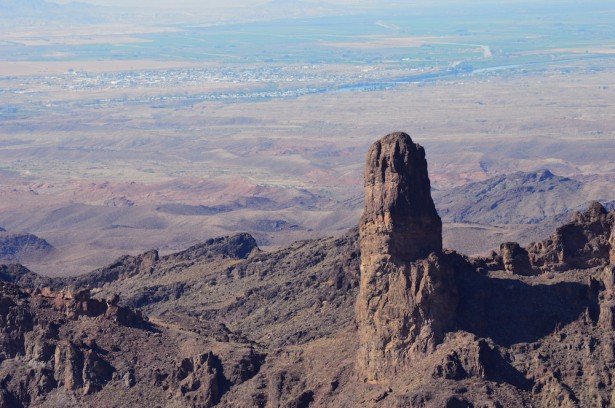
Finger Mountain is the name affectionately given to this part of the Whipple Mountain range west of Parker, AZ. The range can be seen from many miles around and is a recognizable landmark, but few will see the protruding rock formation from this angle. The Colorado River can be seen in the background snaking its way through the desert with river communities on either side, marking the Arizona/California state line.


The correct name for finger mountain is Monument Peak. Any questions call the CRIT Library at 669-1332.
Thank you Elvira!
Hey john , any roads or trails that go to finger mountain?
As I understand it there are trails that go close…. not sure exactly how to do it, but here’s a place to start:
http://offroadinghome.djmed.net/california/california.htm
“THE FINGER”
I can see where Elvira is coming from, as this massif is named in various ways on various maps. I will try her contact.
It seems logical that the name “Monument Peak” should go to the highest point of the massif? One would think that the so called “Finger” is more of a Butte or a Tower than a “Peak”.
Maybe there is a survey benchmark on top?
There is also the confusion of where the Indian Reservation boundary marker is sited? On top of The Peak?
This is more than academic interest as a bunch of us are trying to climb this rascal — or at least get to it’s base! It’s very rugged country!
There are myths and tall tales (and some sketch maps) from The Crossroads community about ATV trails that go to, or even around “The Finger”. We’ve only invested four fruitless days so far in finding such a route.
The various BLM field offices are not of great help, using their limited resources to manage the growing population of us snowbirds down below. The Water Authority are highly paranoid about maintaining a secure zone around their precious domestic water supply line.
We would welcome any suggestions regarding such an access route.
Thanks folks
Rusty Baillie
Climbed it in the early 70’s. Coming from the West side, the closer you get, the harder it is to find.